Hello (and welcome to my first Tropical Update using the new blog!),
June 1st marks the official start of the 2016 Hurricane season. Rainfall at my house totaled 76.20" in 2015, above my 26 year running average of 68.22". Despite a very dry first 6 month of the year, 2015 finished with over 65 inches of rain between July and December. December 2015 was one of the wettest Decembers on record with 13.24" for the month, thanks to our current El Niño.
2015 was a fairly quiet year in the tropics with 11 named storms and 4 hurricanes (see below). South Florida as well as most of the US were spared from significant tropical weather last year. The primary factors for this were a very strong El Niño and below-normal water temperatures in the eastern Atlantic. So far both of these factors remain in place at the present time however the El Niño has been forecast to end this summer and be replaced by a La Niña starting in late July or August. La Niñas are often associated with an increase in hurricane activity due to reduced shear over the Caribbean. Cooler waters in the eastern Atlantic are forecast to persist, which should once again lead to a below-average Cape Verde season. The NHC is forecasting a slightly below-average hurricane season with 10 more named storms (Alex already formed in January) and 7 hurricanes with 2 becoming major hurricanes.
The bottom line is expect a quiet start of the season with an increase in activity late. Areas of greatest risk are the Gulf of Mexico and the US East Coast, with storms forming potentially close to home in the Gulf of Mexico and Western Atlantic.
Risk Areas: One very important statistic to note is that hurricane seasons immediately following a previous year of El Niño conditions almost always have had Gulf of Mexico hurricane, regardless of how many total storms formed during the season. This means that the Gulf of Mexico and particularly the northern and western Gulf Coast has an increased threat for a hurricane impact during the 2016 Hurricane Season.
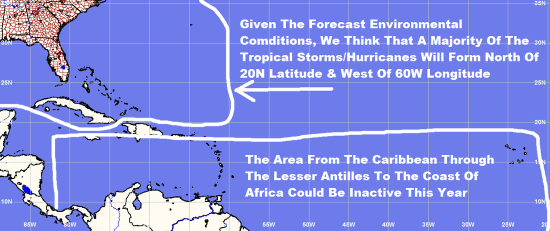
Tropical systems this year should tend to form in the areas north of 20 North Latitude and west of 60 West Longitude.
Wishing everyone a great 2016, and an uneventful Hurricane Season,
Matt
June 1st marks the official start of the 2016 Hurricane season. Rainfall at my house totaled 76.20" in 2015, above my 26 year running average of 68.22". Despite a very dry first 6 month of the year, 2015 finished with over 65 inches of rain between July and December. December 2015 was one of the wettest Decembers on record with 13.24" for the month, thanks to our current El Niño.
2015 was a fairly quiet year in the tropics with 11 named storms and 4 hurricanes (see below). South Florida as well as most of the US were spared from significant tropical weather last year. The primary factors for this were a very strong El Niño and below-normal water temperatures in the eastern Atlantic. So far both of these factors remain in place at the present time however the El Niño has been forecast to end this summer and be replaced by a La Niña starting in late July or August. La Niñas are often associated with an increase in hurricane activity due to reduced shear over the Caribbean. Cooler waters in the eastern Atlantic are forecast to persist, which should once again lead to a below-average Cape Verde season. The NHC is forecasting a slightly below-average hurricane season with 10 more named storms (Alex already formed in January) and 7 hurricanes with 2 becoming major hurricanes.
The bottom line is expect a quiet start of the season with an increase in activity late. Areas of greatest risk are the Gulf of Mexico and the US East Coast, with storms forming potentially close to home in the Gulf of Mexico and Western Atlantic.
Risk Areas: One very important statistic to note is that hurricane seasons immediately following a previous year of El Niño conditions almost always have had Gulf of Mexico hurricane, regardless of how many total storms formed during the season. This means that the Gulf of Mexico and particularly the northern and western Gulf Coast has an increased threat for a hurricane impact during the 2016 Hurricane Season.
Tropical systems this year should tend to form in the areas north of 20 North Latitude and west of 60 West Longitude.
Wishing everyone a great 2016, and an uneventful Hurricane Season,
Matt
2016 Atlantic Tropical Cyclone Names
| Alex Bonnie Colin Danielle Earl Fiona Gaston Hermine Ian Julia Karl | Lisa Matthew Nicole Otto Paula Richard Shary Tobias Virginie Walter |
TROPICAL WEATHER SUMMARY
NWS NATIONAL HURRICANE CENTER MIAMI FL
SEASON SUMMARY 2015
800 AM EST TUE DEC 01 2015
For the North Atlantic...Caribbean Sea and the Gulf of Mexico:
For the 2015 season, 11 named storms formed in the Atlantic basin. Four of the storms became hurricanes, and 2 reached major hurricane status. There was also one unnamed tropical depression. While the number of named storms, hurricanes, and major hurricanes was only a little below the long-term average activity levels of 12, 6, and 3, respectively, many of the named storms were relatively weak and short-lived. As a result, in terms of Accumulated Cyclone Energy (ACE), which measures the combined strength and duration of tropical storms and hurricanes, activity in the Atlantic basin for the season was only about 63 percent of the 1981-2010 median. This makes 2015 a below-average season in terms of ACE.
Reports on individual cyclones, when completed, are available at the National Hurricane Center website at www.nhc.noaa.gov/data/tcr/index.php?season=2015&basin=atl.
Summary Table
